
Data Collection
Luang Prabang Historic District: A 360° Streetscape
Walking Luang Prabang
Explore the historic district of Luang Prabang, Laos, a UNESCO World Heritage Site, through Google Street View. Captured on foot using a 360-degree camera, the imagery offers a pedestrian’s perspective on the town’s streetscapes and scenes of everyday life.
This collection was created with the cooperation of Souphanouvong University and the Luang Prabang World Heritage Office as part of the JSPS KAKENHI-funded project “Fundamental Research on Multisensory Tourism Landscapes.” It documents streetscapes and the spatial connections between places, providing a foundation for examining multisensory tourism experiences in Luang Prabang. It also aims to build a continuing visual record through which changes in the town’s landscape can be traced over time.
The Center for Advanced Tourism Studies (CATS), Hokkaido University, is committed to sharing research materials with local communities and the wider public. As part of this commitment, we hope this archive will support local education and research, deepen understanding of cultural heritage, and encourage residents and visitors to explore Luang Prabang’s streetscapes and reflect on their value and ongoing changes.
Credits and Research Information
- Published by: Center for Advanced Tourism Studies (CATS), Hokkaido University
- With the cooperation of: Souphanouvong University; Luang Prabang World Heritage Office
- Photography: Kyungjae JANG, Center for Advanced Tourism Studies, Hokkaido University
- Date of photography: September 2026
- Capture method: On-foot recording with a 360-degree camera
- Funding: JSPS KAKENHI, Grant-in-Aid for Scientific Research (B), “Fundamental Research on Multisensory Tourism Landscapes” (Grant Number: 25K03369)
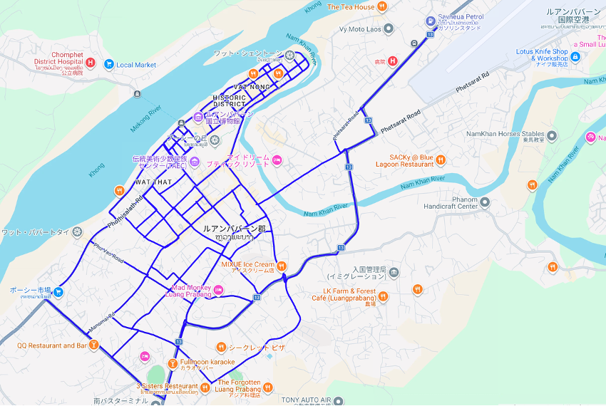
- Coverage area
Walk Through Luang Prabang with Street View
Drag the view to look around, and click the arrows to move along the recorded routes. Explore Luang Prabang’s streetscapes as though you were walking through the town.